

from Wescan Goldfields Inc.
WESCAN GOLDFIELDS IDENTIFIES VISIBLE GOLD AT MUNRO LAKE AND COMPLETES UAV MAGNETIC SURVEY
EQS-News: Wescan Goldfields Inc. / Key word(s): Miscellaneous
WESCAN GOLDFIELDS IDENTIFIES VISIBLE GOLD AT MUNRO LAKE AND COMPLETES UAV MAGNETIC SURVEY
19.10.2026 / 12:35 CET/CEST
The issuer is solely responsible for the content of this announcement.
/NOT FOR DISSEMINATION IN THE UNITED STATES OR FOR DISTRIBUTION TO U.S. WIRE SERVICES/
Highlights:
- Visible gold identified in a quartz vein at surface at the North Vein Target, in the Southeast Zone of the Munro Lake Project
- The principal vein is exposed over a 25-metre strike length, and the vein system is approximately 3 metres wide at surface
- Assays are pending, and the Company will complete channel sampling across the vein
- The vein was the original target of 2013 drill hole EXML-002, which is interpreted to have missed it because the hole was drilled down-dip without accounting for the vein's plunge; deeper in the hole, EXML-002 intersected a second, parallel vein grading 67.1 g/t gold over 1.00 metre*** from 167.70 metres downhole
- Diamond drilling is currently testing the vein, with holes oriented to the vein's recently mapped interpreted average plunge of 63° toward 165° (south-southeast)
- UAV magnetic survey completed: 553.5 line-kilometres flown on 30-metre line spacing, with the full processed data set received for the entire survey area
- A narrow relative magnetic high extends for approximately 1 kilometre along the mineralized trend through the North and South Vein Targets and correlates well with historical gold-bearing grab samples*; it is being used to guide drilling and geological mapping along the trend
- Munro Lake lies 7 kilometres northeast of SSR Mining's Seabee mine and mill complex, Saskatchewan's only producing gold operation**
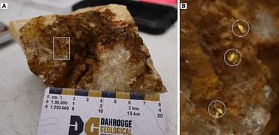
SASKATOON, SK, Oct. 19, 2026 /PRNewswire/ -- Wescan Goldfields Inc. (TSXV: WGF) (FSE: W17A) ("Wescan" or the "Company") is pleased to announce that visible gold has been identified (Figure 1) in a quartz vein exposed at surface at the North Vein Target, in the Southeast Zone of its 100%‑owned Munro Lake Project in northern Saskatchewan, and that the UAV magnetic survey of the project has been completed. The vein is currently being drill tested as part of the Company's Phase 1 diamond drilling program (see Company news release dated October 5, 2026).
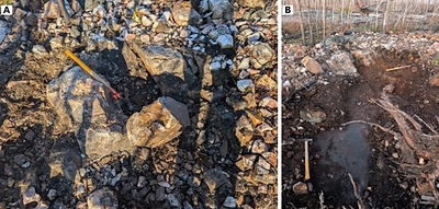
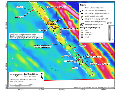
Several grains of visible gold were observed in quartz vein material chiselled from surface at the North Vein Target during the Company's October 2026 field program (Figure 1). Visible gold had not previously been identified at this location, although historical grab samples* collected at the showing in 2012 and 2019 returned between 0.77 and 6.79 g/t gold (five samples). The principal vein is exposed over a 25-metre strike length, and the vein system is approximately 3 metres wide at surface (Figure 2). Samples of the vein, including the material containing visible gold, have been collected and assays are pending. The Company will also complete channel sampling across the vein at surface. The presence of visible gold, while considered encouraging, is not a reliable proxy for assay results: visible gold is not necessarily representative of the gold content of a vein, and visual observations are not a substitute for laboratory analysis.
The vein was the original target of the Company's 2013 drill hole EXML-002, collared approximately 50 metres southwest of the showing and drilled to the northeast (Figure 5). The hole missed the targeted vein but intersected a second, parallel vein deeper in the hole that returned 67.1 g/t gold over 1.00 metre*** from 167.70 to 168.70 metres downhole (see Company news release dated June 17, 2013). The Company interprets that the hole missed because it was designed to test the vein down-dip and did not account for its plunge.
In conjunction with the UAV survey, Chase Wood, P.Geo., M.Sc., of TUZO GeoSurveys Corp. ("TUZO"), whose M.Sc. thesis mapped the adjacent Seabee/Santoy gold complex**, completed structural mapping at the showing (see Company news release dated September 16, 2026). His measurements interprets that the plunge of the vein averages 63 degrees toward an azimuth of 165 degrees (south-southeast) (Figure 5), and the Company is using this plunge to orient the current drill holes.
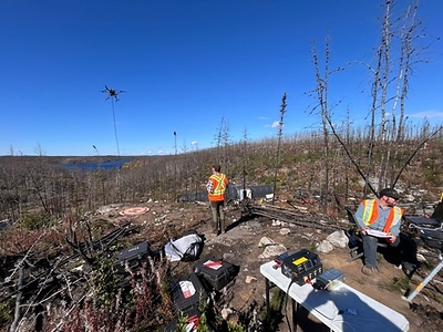
TUZO flew the UAV magnetic survey between September 18 and 24, 2026 (Figure 3). The survey prioritized the western portion of the Munro Lake property, along the prospective geological trend (Figure 4). A total of 553.5 line-kilometres were flown on 30-metre traverse lines oriented northeast–southwest, with tie lines at 300-metre spacing. TUZO has delivered the full processed data set for the entire survey area, including a 3D magnetic susceptibility inversion of its southeast part. A UAV LiDAR survey of the same area was flown on September 17, 2026, and a high-resolution orthomosaic and the final LiDAR products are being compiled.
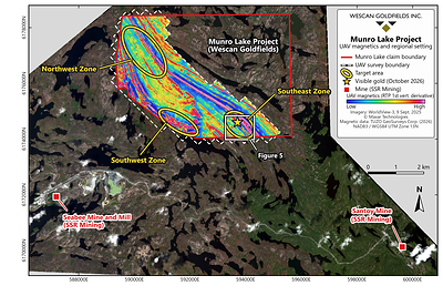
The UAV data resolve the magnetic stratigraphy and structure of the survey area in more detail than the previous airborne magnetic data (Figure 4). In the Southeast Zone, the first vertical derivative of the reduced-to-pole magnetic field defines a narrow, northwest-trending relative magnetic high that extends for approximately 1 kilometre along the interpreted mineralized trend and passes through both the North Vein Target and the South Vein Target (Figure 5). At the South Vein Target, approximately 420 metres southeast of the visible gold showing, historical grab samples* returned up to 6.13 g/t gold, and 2013 drill hole EXML-001 intersected 7.1 g/t gold over 1.02 metres*** from 59.58 to 60.60 metres downhole (see Company news release dated June 17, 2013). The magnetic high correlates well with historical gold-bearing grab samples* along this part of the trend. Gold-bearing quartz veins at Munro Lake commonly contain pyrrhotite, a magnetic iron sulphide, and the Company is evaluating whether the magnetic high reflects the vein system directly. The feature is being used to guide drilling and geological mapping along the trend. The Company also intends to use the UAV data to inform exploration at the Southwest and Northwest target areas (Figure 4).
"The Southeast Zone is a top priority for Wescan," said W. Connor MacNeill, Chief Executive Officer of Wescan. "Identifying visible gold at surface on the north vein target that EXML-002 was originally drilled to test is an encouraging observation, and the drill is now testing that vein along the plunge mapped at the showing. We look forward to reporting assay results as they are received."
* Surface grab samples, by their nature, are selective samples and may not represent underlying mineralization.
** Exploration on adjacent or nearby properties does not guarantee that similar mineralization exists on a specific property.
*** True thickness unknown.
Qualified Person
The scientific and technical information contained in this news release has been reviewed and approved by John Shmyr, P.Geo., of Dahrouge Geological Consulting Ltd., a registered member of the Association of Professional Engineers and Geoscientists of Saskatchewan. Mr. Shmyr is a "Qualified Person" as defined by National Instrument 43-101 – Standards of Disclosure for Mineral Projects ("NI 43-101"). Mr. Shmyr has verified the data disclosed in this news release and consents to the inclusion of the matters based on his information in the form and context in which it appears.
About Wescan Goldfields Inc.
Wescan Goldfields Inc. is a Canadian junior exploration company focused on the exploration and development of gold projects in northern Saskatchewan. The Company holds a 100% interest in four gold projects: the Munro Lake Project, located in the Pine Lake greenstone belt adjacent to the Seabee/Santoy gold camp; and, in Saskatchewan's historic La Ronge Gold Belt, the Jojay Lake Project, which hosts the Jojay gold deposit, the Fork Lake Project, which hosts the past-producing Jasper gold mine, and the recently acquired Lindsay Lake Project.
The Jojay gold deposit is the subject of a historic 2010 NI 43-101 compliant mineral resource estimate completed by A.C.A. Howe International Limited, comprising an Indicated Resource of 420,000 tonnes grading 3.7 g/t gold and an Inferred Resource of 630,000 tonnes grading 4.3 g/t gold (at a 2.0 g/t gold cut-off). The Jasper gold mine was operated by Cameco Corporation in the early 1990s and produced approximately 82,700 ounces of gold from approximately 140,000 tonnes grading 18.9 g/t gold prior to its closure. Shares of Wescan trade on the TSX Venture Exchange under the symbol "WGF".
Important Information Regarding Forward-Looking Statements
Information set forth in this news release may contain forward-looking statements. Forward-looking statements are statements that relate to future, not past, events. Forward-looking statements are often, but not always, identified by the use of words such as "seek," "anticipate," "plan," "continue," "estimate," "expect," "may," "will," "intend," "could," "might," "should," "believe," "scheduled," "to be," "will be" and similar expressions. Forward-looking statements in this news release are based upon the opinions and expectations of management of the Company as of the effective date of such statements. Although the Company believes that the expectations reflected in such forward-looking statements are based upon reasonable assumptions, it can give no assurance that those expectations will prove to have been correct. Forward-looking statements in this news release include, but are not limited to, statements relating to the Company's corporate strategy; the Munro Lake Project and its mineralization potential; the Company's 2026 exploration program, including, but not limited to, the ongoing Phase 1 diamond drilling, the planned channel sampling at the North Vein Target, the anticipated receipt and timing of assay results, the interpretation and use of the UAV magnetic and LiDAR survey data, including to inform exploration at the Southwest and Northwest target areas, and the delivery of the UAV orthomosaic and the final LiDAR products; the Company's objectives, goals, or future plans with respect to its exploration programs; and further exploration work in the future. These forward-looking statements are subject to numerous risks and uncertainties, including those described in the publicly filed documents of the Company, available on SEDAR+ at www.sedarplus.ca. Such risks and uncertainties could cause actual outcomes to differ materially from those anticipated or implied by such forward-looking statements. Accordingly, readers should not place undue reliance on the forward-looking statements contained in this news release, and such forward-looking statements should not be interpreted or regarded as guarantees of future outcomes.
Forward-looking statements are based on the Company and its management's good-faith assumptions relating to the financial, market, regulatory, and other relevant environments that will exist and affect the Company's business and operations in the future. The Company does not give any assurance that the assumptions on which forward-looking statements are based will prove to be correct, or that the Company's business or operations will not be affected in any material manner by those or other factors not foreseen or foreseeable by the Company or management, or beyond the Company's control.
The forward-looking statements contained in this news release are made as of the date hereof, and the Company does not undertake any obligation to update or revise any of the included forward-looking statements, except as required by applicable securities laws in force in Canada. The forward-looking statements contained herein are expressly qualified by this cautionary statement.
Neither the TSX Venture Exchange nor its Regulation Services Provider (as that term is defined in the policies of the TSX Venture Exchange) accepts responsibility for the adequacy or accuracy of this release.
Contact Information: For further information please contact: W. Connor MacNeill, Chief Executive Officer, Email: info@wescangoldfields.com, Phone: (306) 244-5480
 View original content to download multimedia:https://www.prnewswire.com/de/pressemitteilungen/wescan-goldfields-identifies-visible-gold-at-munro-lake-and-completes-uav-magnetic-survey-302912084.html

19.10.2026 CET/CEST Dissemination of a Corporate News, transmitted by EQS News - a service of EQS Group.
The issuer is solely responsible for the content of this announcement.
The EQS Distribution Services include Regulatory Announcements, Financial/Corporate News and Press Releases.
View original content: EQS News
2418072 19.10.2026 CET/CEST